

Explore how AI and computer vision in geology can enable early hazard detection, improve surface analysis, and reveal geological patterns.

Explore how AI and computer vision in geology can enable early hazard detection, improve surface analysis, and reveal geological patterns.
Spotting early signs of change in the landscape, whether it's shifting rock formations, subtle surface movements, or variations in terrain, is a key part of geological research. Traditionally, geologists have relied on fieldwork and manual analysis to observe and interpret these changes.
While effective, these methods can be time-consuming and limited when it comes to detecting subtle patterns over large areas. To support and enhance these efforts, geologists are increasingly relying on AI-powered technologies like computer vision.
Computer vision or Vision AI makes it possible for machines to interpret and understand visual information from the real world. One key reason Vision AI is being used in geology is that the amount of visual data is growing quickly and getting more complex.
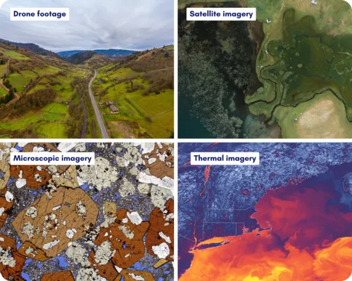
Satellites send back thousands of images every day, drones capture detailed views of large areas, and researchers in labs create high-resolution microscope images of tiny rock samples. Altogether, this creates a huge amount of visual data. Computer vision makes it easier to sort through all this information and find useful and insightful patterns.
For example, computer vision models like Ultralytics YOLO11 can be used to analyze satellite images, drone footage, and lab visuals in geology. Insights from this type of analysis support tasks such as identifying rock types, mapping landforms, and monitoring changes in terrain over time.
In this article, we’ll take a closer look at how computer vision in geology is helping researchers gain deeper insights into our planet. Let’s get started!
Before we dive into the various applications of computer vision in geology, let’s take a step back to understand how Vision AI fits into this field - and where it’s needed the most.
Visual data collected by geologists often needs to be analyzed quickly and accurately to support research and decision-making. This data can reveal important geological patterns. Even very small changes in the landscape or rock structures can provide early signs of larger shifts.
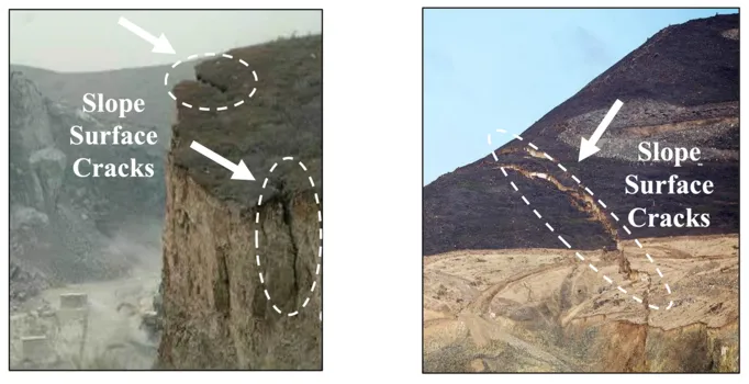
For example, fine surface cracks on a hillside can signal early slope instability and the potential for landslides. While hard to detect manually, computer vision can quickly and reliably identify these subtle changes.
Here are some other ways in which AI and computer vision are currently being used in geology:
Different types of visual data allow geologists build a clearer picture of what’s happening both on the surface and beneath the Earth. Here are some of the main types of visual data used in geology and how each one supports our understanding of the planet:
Now that we have a better understanding of the types of visual data geologists work with, and how computer vision can help analyze them, let’s walk through a few interesting applications of computer vision in geology that showcase its potential to enhance research and discovery.
Before a volcano erupts, there are often early warning signs like changes in surface temperature, gas release, or small movements in the ground. These signs can be difficult to spot, especially in remote areas.
Computer vision models are now being used to analyze satellite and thermal imagery to monitor volcanic activity more efficiently. These systems can measure the height and temperature of ash plumes, detect heat on the volcano’s surface, and notice small changes in its shape - signals that could mean an eruption is coming.
An interesting example of this is the DeepCube H2020 project, which uses computer vision techniques like image classification and instance segmentation to analyze Synthetic Aperture Radar (SAR) data. SAR is a type of satellite imaging that uses radar instead of light, allowing it to capture detailed images of the Earth's surface regardless of weather conditions or time of day.
By comparing SAR images taken over time, the system can detect small ground movements near volcanoes that may signal early signs of unrest. This research helped lead to the development of Pluto, an AI-powered global alert system that monitors volcanoes and sends early warnings when signs of activity are detected.

Consider a mining company assessing a new site for resource exploration. Before any drilling can begin, geologists typically need to identify the types of rocks in the area to assess both the mineral potential and any safety risks. Traditionally, this involves collecting physical samples and analyzing them by hand - a method that’s not only time-consuming but also depends heavily on expert judgment.
With the help of machine learning and computer vision, this process is becoming faster and more objective. High-resolution images of rock samples are captured and analyzed by trained models that can recognize patterns in texture, color, and grain structure using computer vision tasks like image classification.
These models learn from thousands of labeled rock images, so they can quickly and accurately identify new samples on their own. This speeds up decision-making in the field and reduces the need for extensive manual work, making exploration more efficient and consistent.
Identifying fault lines and fractures in rock formations traditionally required extensive fieldwork. Today, computer vision models can analyze satellite and aerial imagery to automatically detect these features with high accuracy. By spotting linear patterns that indicate fault lines, these models help create detailed maps of geological risk zones.
Computer vision models like YOLO11 that support tasks like instance segmentation can be used to detect cracks, fractures, and fault lines in surface imagery. These models can identify even small cracks in rock or soil, which improves geological mapping and supports safer planning for construction or drilling in earthquake-prone areas.

Computer vision is transforming geological workflows, from identifying minerals to better understanding what lies beneath the surface. Here are some of the key benefits it brings to the field:
However, despite its advantages, applying computer vision in geology also comes with a few challenges to consider:
Computer vision is becoming an impactful tool that is reinventing how geological research and applications are carried out. From monitoring volcanic activity to detecting early warning signs of landslides, Vision AI-driven tools are helping geologists improve both research outcomes and disaster response strategies.
Looking ahead, as AI continues to evolve and more data from various sensors is integrated, we can expect the development of more robust systems designed for real-world field use. Computer vision will likely become a core component of geological practices, enhancing both efficiency and accuracy across a wide range of applications.
Join our community and explore our GitHub repository to learn more about computer vision in action. If you're interested in how AI is being applied across industries, visit our solutions page to discover real-world use cases - from computer vision in manufacturing to AI in healthcare. Check out our licensing options and take the first step toward building with computer vision today.