

Learn how using Vision AI to monitor climate change can track environmental shifts and provide valuable insights for faster responses to climate-related events.

Learn how using Vision AI to monitor climate change can track environmental shifts and provide valuable insights for faster responses to climate-related events.
Happy Earth Day! Every April 22nd, people around the world take a moment to celebrate our planet and think about how we can take better care of it. With climate change accelerating, Earth Day is a great opportunity to explore what we can do to make a positive impact and create a more sustainable future.
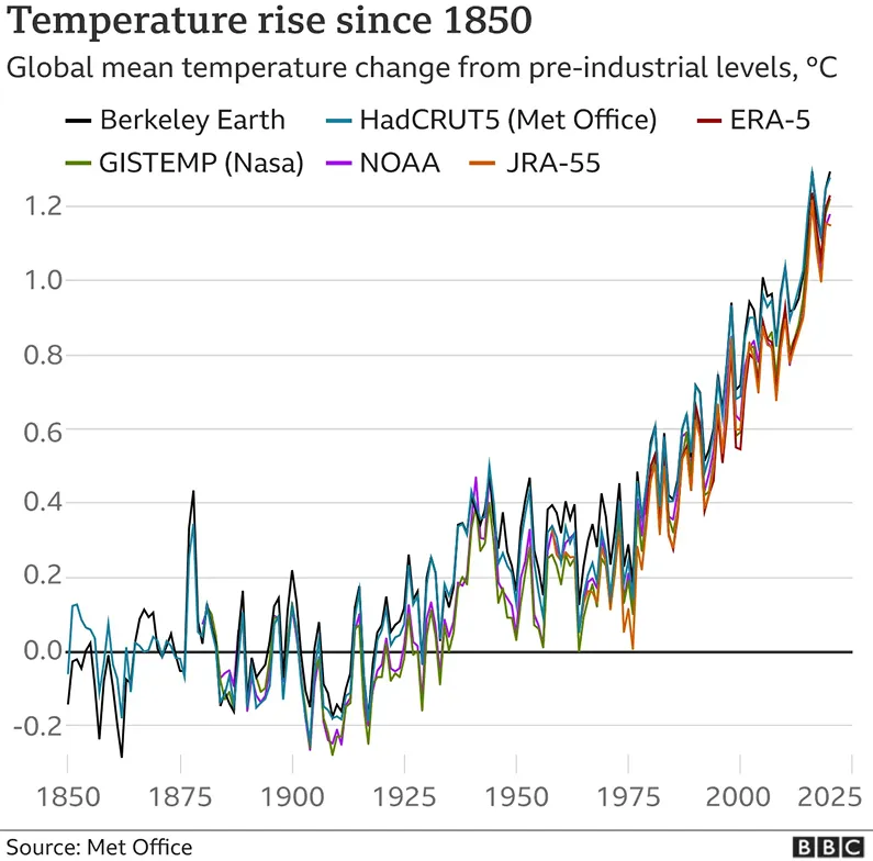
This is especially important considering that in 2024, global temperatures hit a record high, leading to faster ice melt and rising sea levels. These changes are impacting ecosystems worldwide and happening rapidly.
Traditional climate monitoring methods are struggling to keep up with the pace and scale needed. This is where AI technologies like computer vision, which analyzes images and video, can make a difference.
For example, computer vision models like Ultralytics YOLO11 support tasks like object detection and instance segmentation, helping track and identify environmental changes in real time with higher accuracy and speed.
In this article, we’ll explore why using Vision AI to monitor climate change is so important and how it's transforming the process. Let’s get started!
Conditions on Earth are constantly changing. But in recent years, the pace and scale of those changes have become harder to ignore. Shifting weather patterns, rising temperatures, and altered landscapes are becoming more apparent, highlighting the need for better monitoring and response systems.
For example, in southern Brazil in 2024, weeks of unexpected heavy rainfall caused water levels to rise dangerously across several regions. However, thanks to early monitoring systems, communities in affected areas were able to prepare and respond in time.
Events like this showcase how timely information can make all the difference. It supports early warnings, shapes better planning, and reduces the risk of natural disasters. While traditional methods like field surveys or isolated sensors can provide helpful information, they often fall short.
That’s why more advanced approaches are gaining attention. By using smarter technologies to observe the planet, we can stay ahead of change and make decisions based on what’s happening in real time.
Computer vision is playing an increasingly important role in how we monitor environmental changes. With Vision AI models like YOLO11, it's possible to track shifts in the environment quickly, accurately, and across large areas.
Here are some of the key ways in which computer vision is being used to monitor climate change:
Vision AI models like YOLO11 go beyond simply processing images; they enable specialized computer vision tasks like object tracking, image classification, and pose estimation. These tasks help identify patterns, detect anomalies, and track environmental changes with greater accuracy.
Let’s explore some key computer vision tasks and how they contribute to addressing climate change.
Object detection is a computer vision technique that can be used to identify and locate specific objects within images or videos. It can detect things like fire, smoke, vehicles, animals, or debris, which may indicate a threat or environmental change.
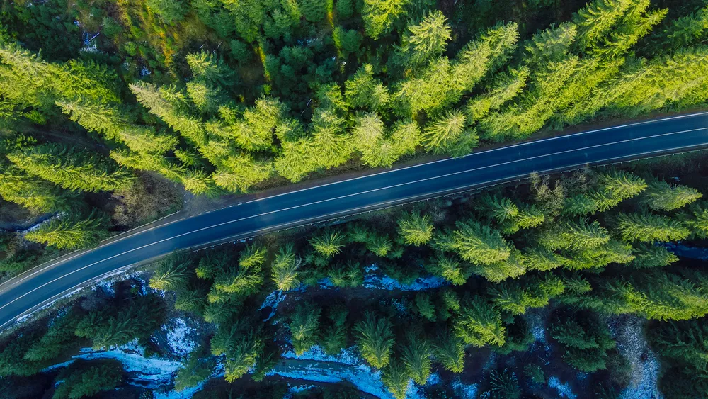
This technology is especially useful for early warning systems. For example, wildfires, which are becoming more frequent and widespread due to hotter and drier conditions, can be detected early through signs like smoke or flames. Object detection helps AI systems recognize these signs quickly, enabling a faster response to minimize damage.
By detecting threats early, emergency teams have more time to act, helping to protect forests, homes, and air quality.

While object detection identifies specific objects within an image, image classification assigns a single label to an entire image based on its dominant feature, like "forest," "snow," "water," or "urban area."
With respect to environmental monitoring, image classification is commonly used for land use and land cover analysis. This method helps track large-scale changes in the environment, such as deforestation, urban expansion, or changes in bodies of water. By classifying large regions of land, image classification provides valuable insights into long-term environmental shifts and trends.
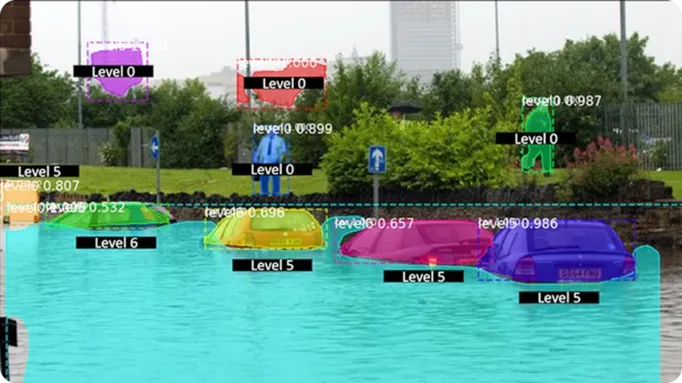
In situations like an unexpected flood caused by climate change, we need to know exactly where the flood is having an impact, how much damage it is causing, and what is being affected. That’s where instance segmentation becomes essential.
Unlike image classification, which labels the whole image, instance segmentation works at the pixel level. It outlines individual features in an image, such as flooded roads, submerged vehicles, or shifting coastlines. Segmentation can help gather detailed insights that can support both rapid emergency responses and long-term climate adaptation plans.
Now that we’ve discussed how computer vision tasks can be used, let’s explore how computer vision can be applied in real-world climate projects, turning visual data into insights for faster, smarter action.
Researchers are using computer vision to monitor glaciers and the impact of climate change. By analyzing satellite images, computer vision models can identify areas of water and ice, mapping the shape and size of glacial lakes using object detection and segmentation techniques.
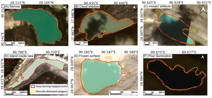
These automated systems can provide real-time updates on how glaciers are retreating and where new lakes are forming. This data helps local authorities improve early warning systems for potential floods, especially in vulnerable regions. Also, the insights gained are crucial for long-term planning in water management and addressing the challenges posed by rising sea levels.
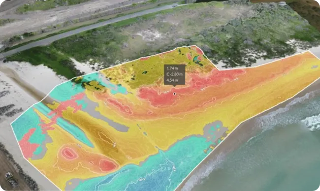
Coastal areas around the world are seeing rising sea levels and more frequent storms, which are contributing to faster erosion. Unfortunately, this can impact homes, roads, and natural habitats.
However, drones integrated with vision AI models can be used to capture high-resolution images of coastlines over time. These models analyze shifts in the shoreline by comparing images taken on different dates.
The data collected provides valuable insights for local governments, helping them identify high-risk areas before further damage occurs. It also supports larger-scale climate adaptation efforts, such as planning where to build seawalls or restore natural buffers like dunes and wetlands.
Here are some of the key benefits that Vision AI brings to environmental monitoring and climate response:
While these benefits highlight how Vision AI is redefining climate applications, it's also important to consider the challenges that come with using these systems effectively.
Here are some of the key limitations of using computer vision for climate monitoring:
Earth Day is a great reminder to reflect on how our planet is changing and what we can do to keep it safe. With tools like Ultralytics YOLO11, computer vision solutions help us track environmental shifts and make informed decisions based on real-time data.
For example, Vision AI models can analyze vast amounts of imagery, offering insights into changes happening in forests, oceans, and cities. By leveraging computer vision, we can act faster and more effectively to protect our planet.
Curious about Vision AI? Explore our GitHub repository and connect with our community. Learn more about real-world applications like AI in manufacturing and Vision AI in agriculture. Check out our licensing options and get started on a computer vision project today!